


From Gallis to Expressways: How Lucknow’s Roads Became the Arteries of a Modern Metropolis
From Gallis to Expressways: How Lucknow’s Roads Became the Arteries of a Modern Metropolis
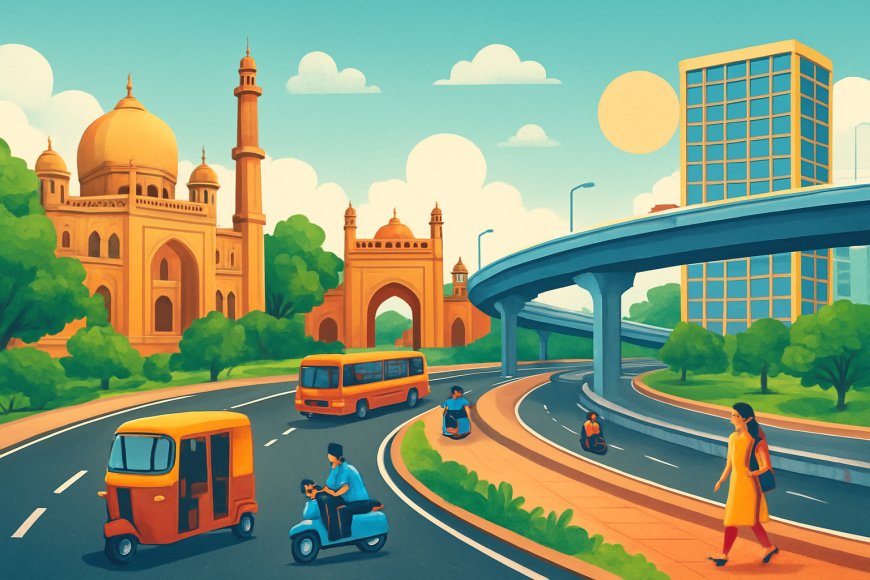
Lucknow: In the heart of Uttar Pradesh, Lucknow—once the glittering capital of the Awadh kingdom—has long been synonymous with grandeur, kebabs, and chikankari embroidery. Yet beneath this cultural veneer lies a pulsating story of urban evolution, etched in asphalt and concrete: the city’s road network. From the narrow, winding gallis of the Nawabi era to the sprawling expressways of the 21st century, Lucknow’s roads have mirrored India’s broader journey from colonial subjugation to an economic powerhouse.
The Nawabi Foundations: Roads as Royal Whims (18th–19th Century)
Lucknow’s road story begins in the 18th century, when the Nawabs of Awadh infused the city with Persian aesthetics and royal indulgence. Asaf-ud-Daula, the fourth Nawab, shifted the capital from Faizabad to Lucknow in 1775, ushering in a new era of planned urban growth. The roads of this period were not merely transport links—they were expressions of royal identity.
The iconic Chowk area, still one of the busiest markets in the city, took shape as a dense network of lanes built for foot traffic, palanquins, elephant processions, and horse-drawn carriages. These routes were unpaved, dusty, and organic in design—reflecting the aristocratic, leisurely rhythms of the time.
British East India Company archives describe a fledgling version of Hazratganj, then an avenue lined with imambaras, palaces, and the occasional European-influenced bungalow. Nawab Saadat Khan laid the foundation with the construction of wooden bridges over the Gomti, facilitating trade in musk, silk, and ittar. By the mid-19th century, under Wajid Ali Shah, Lucknow boasted more than 100 kilometers of interconnected roads, many paved with kankar stones to withstand monsoons.
But the 1857 uprising disrupted this elegance. British forces, during the siege of Lucknow, destroyed sections of the Residency road network. After annexing Awadh in 1856, colonial administrators imposed a stark grid pattern in the Cantonment area—straight, tree-lined avenues inspired by Haussmann’s Paris. La Place, today’s Hazratganj, evolved into a European-style boulevard.
By 1900, Lucknow’s road network expanded to around 200 km, blending cobblestones, macadamized surfaces, and the emerging railway infrastructure—marking the beginning of modern mobility.
Colonial Legacy and Early Independence: From Horse Carts to Motorcars (1900–1980)
With the early 20th century came the motorcar. The first automobile is said to have rolled into Lucknow in 1904, forcing road planners to widen major routes. By the 1920s, the British introduced tar-macadam roads, expanding the network to nearly 500 km by 1947.
The pre-Independence era also witnessed significant transport corridors such as the Lucknow-Agra Road—an early precursor to today’s national highways. Post-1947, India's planners saw urban connectivity as central to nation-building. Lucknow, being the state capital, benefited immensely.
During the 1950s, the 10-km Charbagh Railway Station ring road eased congestion around the bustling station, especially after the influx of Partition refugees. The 1960s and 1970s witnessed a construction boom, led by Chief Ministers Sucheta Kripalani and Chandra Bhanu Gupta.
The 1970 Gomti Barrage enabled riverfront roads and embankments, adding 20 km of smooth movement across the city. In 1972, the Dalibagh Flyover became Uttar Pradesh's first major elevated road, at a cost of ₹50 lakh. By 1980, Lucknow had over 1,200 km of motorable roads.
Yet the era also faced limitations. A surge in cycle-rickshaws, population growth, and the 1970s oil crisis strained the network. Senior historian Dr. Roshan Taqui recalls, “In the 1960s, the rickshaw ride from Aminabad to Hazratganj took thirty minutes. Today, you might get stuck for that long just leaving the crossing.”
The Liberalization Leap: Lucknow Steps onto the National Highway Map (1980–2000)
Economic reforms in 1991 reshaped the nation—and Lucknow’s landscape. The city’s population ballooned from one million in 1981 to 1.6 million in 1991, driving exponential growth in road infrastructure.
Prime Minister Atal Bihari Vajpayee’s Golden Quadrilateral project (1999) brought Lucknow closer to the heart of national connectivity. Though the city itself was not part of the four-way grid, the Delhi–Kanpur–Lucknow corridor strengthened significantly.
The 1998 opening of the Lucknow–Kanpur Expressway (NH-25) was transformative, reducing travel time from four hours to 90 minutes. Ring Road Phase I (1995), a 25-km semicircular bypass, diverted heavy trucks from congested inner lanes.
Traffic lights made their debut, with Parivartan Chowk receiving Lucknow’s first automated signaling system in 1996. By 2000, the city’s road network grew to 2,500 km.
Environmental and social concerns also emerged. Rising pollution in the Gomti forced stricter riverfront planning, while women's safety improved with better-lit medians in areas like Hazratganj.
The Millennium Boom: Expressways, Metros, and Smart Urban Corridors (2000–2020)
The 21st century marked Lucknow’s boldest infrastructural expansion. After 2002, the Uttar Pradesh State Highways Authority accelerated major projects.
The 302-km Lucknow-Agra Expressway, inaugurated in 2016, became India’s longest expressway at the time. Built at a cost of ₹15,000 crore, it included solar lighting and emergency airstrips. Travel time to Agra halved to three hours, boosting tourism and trade.
Urban mobility received a revolutionary upgrade when the Lucknow Metro began operations in 2017. The 23-km North–South corridor reduced congestion significantly, integrating seamlessly with road underpasses and elevated stretches. According to LMRC, peak-hour traffic reduced by nearly 20% in the first year alone.
The Outer Ring Road (104 km), completed between 2016 and 2020, encircled the city, linking it with the Purvanchal Expressway (341 km, opened in 2021). Infrastructure became central to political vision—particularly during the Akhilesh Yadav government, which added nearly 1,000 km of state highways.
By 2020, Lucknow featured over 5,000 km of roads, 40 flyovers, and 15 underpasses. Even during the COVID-19 crisis, its network enabled emergency movement and vaccine logistics, with Amar Shaheed Path emerging as a critical spine.
Contemporary Challenges and the Road Ahead (2020–Present)
Today, in 2025, Lucknow’s population stands close to four million. Vehicle registrations have crossed 2.5 million. The road length exceeds 6,500 km, as per the Lucknow Municipal Corporation. Yet congestion, flooding, and rapid urbanization continue to challenge planners.
Gomti Nagar, Aliganj, and old Lucknow still grapple with monsoon inundation due to outdated drainage. Land acquisition delays such as the stalled Inner Ring Road highlight the friction between development and livelihoods. Encroachments in Chowk and Aminabad persist, defying regulatory attempts.
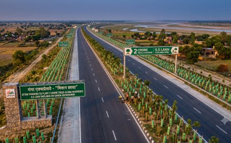
The Yogi Adityanath government has introduced ambitious upgrades. The Lucknow–Kanpur Expressway expansion (2023) is underway. The massive Ganga Expressway, slated for completion in 2025, will link Lucknow seamlessly with western Uttar Pradesh.
Smart City initiatives include AI-driven traffic management at 50 intersections, achieving a 15% reduction in waiting time. Since 2021, over 200 km of cycle tracks have been added, aligning with the LMC’s 2031 Master Plan. The Shaheed Path Extension incorporates green medians featuring native species to reduce urban heat.
Electric mobility is also shaping Lucknow’s future. Dedicated lanes for e-buses, launched as a pilot in 2024, are expected to reduce pollution and streamline public transport.
Urban planner Dr. Meera Srivastava sums up the sentiment: “Roads are Lucknow’s veins, pumping life into its tehzeeb and its future. The city cannot stop building—but it must build wisely.”
From Nawabi gallis to smart expressways, Lucknow’s road journey is a testament to its resilience, ambition, and evolving identity. Its roads do not simply connect spaces; they connect eras, cultures, and aspirations—driving the city toward a modern destiny while echoing the footfalls of its royal past.
What's Your Reaction?